
Simple GIS Client - Why Pay More?
Simple GIS Mapping Software for Windows
Create professional maps, analyze spatial data, and geocode addresses without expensive enterprise GIS software.
Simple GIS Client is an affordable desktop GIS mapping solution for Windows that combines mapping, geocoding, spatial analysis, GPS tracking, and shapefile editing in one easy-to-use application.
Key GIS Mapping Features
Professional Thematic Mapping
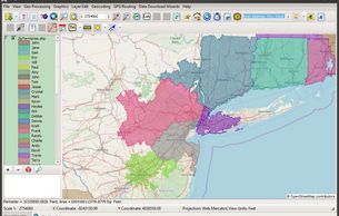
Create layered maps with custom symbology, legends, and annotations. Import shapefiles, GeoJSON, KML, Excel, and CSV data.
Fast Offline Geocoding & Street Address Mapping
Batch geocode Excel or CSV address lists using built-in offline geocoding. Map ZIP codes, counties, states, and custom boundaries.
Spatial Analysis Tools
Perform buffers, drive-time analysis, attribute queries, spatial joins, and calculated fields.
GPS Tracking & Routing
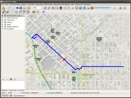
Track location, record GPX files, and create multi-stop routes with turn-by-turn navigation.
Imagery & Elevation Processing

Georeference imagery, generate shaded relief maps, create heat maps, and analyze elevation profiles.
Shapefile & Data Editing
Edit shapefiles with snapping, polygon split, trimming, and custom data entry forms without coding.

Get a Free Trial!
✔ Free trial — no credit card
✔ Install locally on Windows
✔ Test with your own data
✔ Full feature access
Ready to Map, Geocode, and Analyze Without the Hassle?
Simple GIS Client gives you the power of professional GIS software without subscriptions, cloud lock-in, or unnecessary complexity.
Looking to Purchase?
Users can purchase licenses as a subscription or as a perpetual license depending on individual user needs. Click our pricing button below to see all of our purchase options.