.jpg/:/cr=t:0%25,l:0%25,w:100%25,h:100%25/rs=w:1209,h:653)
Simple GIS Client - Why Pay More?
Best Shapefile Software for GIS – View, Edit, & Create Maps
Get powerful shapefile software for Windows that lets you view, edit, create, and analyze ESRI shapefiles and other spatial data formats — without high enterprise costs. Perfect for mapping professionals, planners, analysts, and teams looking for an easy, affordable GIS solution.
Why Choose Our Shapefile Software

Shapefile Viewing, Editing & Creation
- Open and manipulate ESRI shapefiles and attribute data.
- Edit geometry with vertex editing, snapping, and advanced split/trim tools.
- Create new shapefiles with custom fields and geospatial attributes.
Professional Mapping & Visualization
- Design thematic maps with custom symbols and legends.
- Add multiple layers with on-screen customization.
Spatial Analysis & Queries
- Perform buffer, overlay, and spatial queries for feature analysis.
- Join geographic data from US Census and OpenStreetMap.
Batch Geocoding & Data Import
- Map Excel/CSV data by address or coordinate.
- Generate shapefiles from address lists and tabular records.
GPS Tracking & Routing
- Integrate GPS devices for real-time routing, navigation, and field data capture.
Key Features
Powerful Editing Tools
Easily create and edit shapefiles. Simple GIS supports vertex editing and snapping as well as advanced editing functions such as clipping, line trim, polygon split, node move, COGO (Metes & Bounds) editing and more! Simple GIS Client even allows you to design your own data entry forms with no coding. One of the most feature rich shapefile software programs you'll find!
Professional Quality Maps
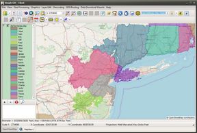
Simple GIS Client is powerful GIS mapping software that supports thematic mapping. Easily add multiple layers, each with it's own custom legend and symbology. Locate & download data using the built in USGS data wizard. Use Simple GIS Plugins for additional features such as Territory Mapping or publishing Web Mapping applications
Powerful Spatial Analysis Capabilities
Powerful Spatial Analysis Capabilities
Easily create attribute or spatial queries. Perform buffer analysis, drive time analysis, or create calculated fields. Also contains built in data wizards for downloading and analyzing data from the US Census Bureau, USGS Department, or ©OpenStreetMap.
Map Excel Data by Street Address
Powerful Spatial Analysis Capabilities
Have data in Excel or CSV files? Use the batch geocoding tool in Simple GIS Client or the Address Mapping Project Template to map these points. You can also take a list of zip codes, county names, or state names and map to these boundaries.
GPS Tracking and Routing Support
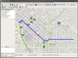
Connect to on-board or externally connect GPS devices that support the NMEA 0183 protocol or Windows 10 sensor platform. Create multi-stop routes, track your GPS location in the field or use the turn by turn navigation support. Can also record your position as GPS breadcrumbs as well as read and write GPX files.
Powerful Imagery Geo-processing Capabilities

Geo-reference Imagery, create shaded relief imagery from elevation data, generate heat maps, or elevation profiles from elevation data. All of this can be easily accomplish in Simple GIS Client

Try It Now — Free Simple GIS Client Shapefile Software Trial
✔ Free trial — no credit card
✔ Install locally on Windows
✔ Test with your own data
✔ Full feature access
Ready to View, Edit, or Create Shapefiles Without the Hassle?
Simple GIS Client gives you the power of professional GIS software without cloud lock-in or unnecessary complexity.
Looking to Purchase?
Users can purchase licenses as a subscription or as a perpetual license depending on individual user needs. Click our pricing button below to see all of our purchase options.