
Powerful GIS Software for Windows - Why Pay More?
Simple GIS Client- Powerful Desktop GIS & Geocoding Software
Tired of expensive and complicated GIS software systems that require a steep learning curve and large investment?
Fast, affordable desktop GIS software with powerful mapping, batch geocoding, offline street maps, and GPS support.
✔ No per-record geocoding fees
✔ Works fully offline
✔ Free trial available
Desktop GIS Software for Windows
Why Users Choose Simple GIS Client
✔ Desktop GIS — not browser-based
✔ Integrated GIS mapping + geocoding software
✔ Unlimited batch address geocoding
✔ Offline street maps and GPS support
✔ Fast performance on large datasets
✔ One-time license option available
Simple GIS Client delivers the essential tools of modern GIS software without unnecessary complexity.

Key Features of Simple GIS Client
Professional Quality Maps
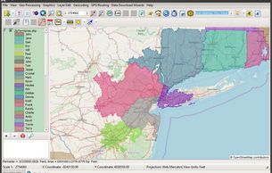
Create professional maps in Simple GIS using:
- Thematic & choropleth mapping
- Attribute-driven styling
- Spatial queries and selections
- Buffers, overlays, and proximity analysis
Result: Clear, publication-ready maps without GIS bloat.
Batch Geocoding & Street Address Mapping
Turn address lists into mapped locations in minutes.
- Import Excel or CSV files
- Batch geocode thousands of addresses at once
- No API keys, no usage limits
- Offline geocoding supported
Result: Faster address mapping at zero per-record cost.
Offline GIS with Street Maps & GPS
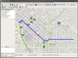
Perfect for field work and mobile operations.
- Detailed offline street atlas datasets
- GPS device connectivity
- Live tracking & breadcrumb trails
- Route visualization
Popular with former DeLorme Street Atlas users.
Powerful Spatial Analysis Capabilities
Easily create attribute or spatial queries. Perform buffer analysis, drive time analysis, or create calculated fields. Also contains built in data wizards for downloading and analyzing data from the US Census Bureau, USGS Department, or ©OpenStreetMap. Simple GIS Client contains many features not even found in much more expensive GIS Software solutions.
Powerful Imagery Geo-processing Capabilities

Geo-reference Imagery, create shaded relief imagery from elevation data, generate heat maps, or elevation profiles from elevation data. All of this can be easily accomplished in Simple GIS Client
Full Shapefile Editing & Data Control
Edit points, lines, and polygons
- Modify attributes and calculated fields
- Import/export standard GIS formats including shapefiles
- Work with parcels, census data, and boundaries
Result: Total control over your GIS data.
Real world results
“756,734 addresses matched with a 92.7% success rate — faster and equal or better than ArcGIS geocoding, without per-record charges.”
— Frank M. Howell, PhD, Mississippi State University


Try It Risk-Free
✔ Free trial — no credit card
✔ Install locally on Windows
✔ Test with your own data
✔ Full feature access
Ready to Map, Geocode, and Analyze Without the Hassle?
Simple GIS Client gives you the power of professional GIS software without cloud lock-in or unnecessary complexity.
Looking to Purchase?
Users can purchase licenses as a subscription or as a perpetual license depending on individual user needs. Click our pricing button below to see all of our purchase options.
See Latest News About Simple GIS Client
Unlocking the Power of Spatial Analysis in Simple GIS Software
Unlocking the Power of Spatial Analysis in Simple GIS Software
Unlocking the Power of Spatial Analysis in Simple GIS Software
Geographic Information Systems (GIS) have become integral tools for professionals across various industries, enabling them to analyze, interpret, and visualize spatial data...
Harnessing the Power of OpenAerialMap Imagery in Simple GIS
Unlocking the Power of Spatial Analysis in Simple GIS Software
Harnessing the Power of OpenAerialMap Imagery in Simple GIS
Geographic Information Systems (GIS) have become indispensable tools in today's world, serving a multitude of purposes, from urban planning and environmental management to disaster response and agriculture...
Simple GIS Client Version 15 Released!
Simple GIS Releases It's 2026 US Street Atlas Dataset!
Harnessing the Power of OpenAerialMap Imagery in Simple GIS
This page tracks all updates and releases to Version 15 of Simple GIS Client, our desktop GIS mapping software.
Simple GIS Releases It's 2026 US Street Atlas Dataset!
Simple GIS Releases It's 2026 US Street Atlas Dataset!
Simple GIS Releases It's 2026 US Street Atlas Dataset!
Simple GIS is pleased to announce that it has updated its US Street Atlas Dataset. The US Street Atlas Dataset is available for download via the Street Atlas Project template or the OpenStreetMap data wizard in Simple GIS Client ...
Reprojecting Vector Data in Simple GIS Client
Simple GIS Releases It's 2026 US Street Atlas Dataset!
Simple GIS Releases It's 2026 US Street Atlas Dataset!
The ability to reproject data from one map projection to another is critical in any GIS application as users commonly find themselves working with data stored in different map projections ...