Simple GIS Software

Simple GIS SoftwareSimple GIS SoftwareSimple GIS Software

Simple GIS Software

Simple GIS SoftwareSimple GIS SoftwareSimple GIS Software
  • Home
  • Products
  • Simple GIS - Pricing
  • Reviews
  • Tutorials
  • Contact Us
  • News
  • Free GIS Resources
  • About
  • Online Training Request
  • More
    • Home
    • Products
    • Simple GIS - Pricing
    • Reviews
    • Tutorials
    • Contact Us
    • News
    • Free GIS Resources
    • About
    • Online Training Request
  • Home
  • Products
  • Simple GIS - Pricing
  • Reviews
  • Tutorials
  • Contact Us
  • News
  • Free GIS Resources
  • About
  • Online Training Request
Example of GPS tracking and Routing in Simple GIS Client
Simple GIS Client - Why Pay More?

GPS Mapping Software for Windows

Lightweight GPS Mapping Software for Windows Laptops & Tablets​

​Great for offline GPS tracking, navigation, and GIS analysis from your Windows laptop or tablet device. 

 ✔ Free Trial – No Signup Required
✔ Works Offline – No Internet Needed
✔ Connect Any GPS (NMEA 0183 Supported)
✔ Turn-by-Turn Navigation + GIS Tools 

Start Free Trial!

All-in-One GPS Mapping + GIS Software

Simple GIS Client combines GPS navigation with professional GIS capabilities so you can:

  • Track your position in real-time
  • Create routes and navigate in the field
  • Map GPX, Excel, or shapefile data
  • Perform spatial analysis and territory mapping


Unlike basic GPS tools, it’s a full desktop GIS + GPS solution.

WHO IT’S FOR

Perfect for:

  • Field technicians & inspectors
  • Utility and infrastructure teams
  • Surveying & land management
  • Oil & gas operations
  • Sales territory mapping
  • Government & planning agencies

What our customers are saying

Pros: "The ease of downloading aerials and USGS maps, the deed plotter feature and the fact that it has a GPS feature that enables me to take my laptop into the field and mark corners, etc."        

              Don B.
​              Red Group Auctions

Key Features

GPS Tracking & Navigation

  • Real-time GPS tracking using NMEA-compatible devices
  • Turn-by-turn routing on your laptop
  • Record and export GPS breadcrumbs (GPX)
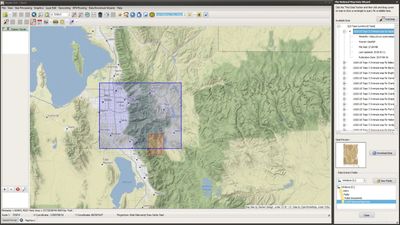
Offline Mapping

Territory Mapping in Simple GIS Client

  • Download full street maps for offline use
  • No internet required in the field
  • Reliable in remote environments

Advanced GIS Tools

Map Your Data Instantly

  • Buffer zones & drive-time analysis
  • Spatial queries and data filtering
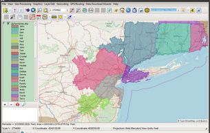
  • Census and demographic mapping

Map Your Data Instantly

Map Your Data Instantly

  • Import Excel, CSV, GPX, shapefiles
  • Batch geocode addresses
  • Visualize data geographically

Powerful Imagery Geo-processing Capabilities

Imagery processing in Simple GIS Client

  • Geo-reference Imagery
  • Create shaded relief imagery from elevation data
  • Generate heat maps Generate elevation profiles from elevation data

Powerful Editing Tools

  • Easily create and edit shapefiles  
  •  Supports vertex editing and snapping
  • Advanced editing functions such as clipping, line trim, polygon split, node move, and more!

WHY CHOOSE SIMPLE GIS?

Using the USGS Data Wizard in Simple GIS Client

Try It Risk-Free

✔ Free trial — no credit card

✔ Install locally on Windows

✔ Test with your own data

✔ Full feature access


 No cloud. No complexity. No enterprise pricing. 

Try It Free!

Looking to Purchase?

Users can purchase licenses as a subscription or as a perpetual license depending on individual user needs. Click our pricing button below to see all of our purchase options.

Simple GIS Client Pricing

Frequently Asked Questions

Please reach us at contactus@simplegissoftware.com if you cannot find an answer to your question.

Yes — download maps and use GPS tracking without internet.


Yes — supports NMEA 0183 GPS devices.


Yes — full GPX import/export support.


Both — combines GPS navigation with full GIS capabilities.


What Our Customers Are Saying


Copyright © 2020 Simple GIS Software LLC - All Rights Reserved.


Simple GIS Software provides desktop GIS mapping, geocoding, shapefile editing, and spatial analysis tools for Windows users who need powerful geographic capabilities without enterprise cost. The software supports address mapping, census data visualization, GPS tracking, and territory creation — all running locally on your computer for speed, reliability, and data control.

Popular uses include address geocoding, sales territory mapping, government planning, infrastructure mapping, and demographic analysis.

  • Simple GIS - Pricing
  • Contact Us
  • Cookie Policy
  • Privacy Policy
  • Online Training Request

Powered by

This website uses cookies.

We use cookies to analyze our website traffic for the purpose of improving performance and user experience.  By browsing our website, you consent to our use of cookies. 

OK